Detail
Gsteig - Walliser Wispile (1982 M.a.s.l)
5,10 km
2:20 hrs.
802 m
2 m
84
TOP Moderate
Best season
JanFebMarAprMayJunJulAugSepOctNovDec
Download
Starting point of the tour
Gsteig (1183 M.a.s.l)
Destination of the tour
Walliser Wispile (1982 M.a.s.l)
Lowest point
1.183 m
Highest point
1.982 m

Properties
- Scenic
- Summit route
- suitable for snowboards
- Forest roads
- Clear area
- Forest


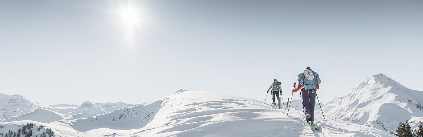
The extension of the Wispile towards Wallis, which rises between the valleys of Lauenen and Gsteig, is always worth a ski tour. Especially in the high winter, when a lot of fresh snow has fallen, a winter storm is raging on the surrounding high alpine peaks or the danger of avalanches does not allow major ski tours, the Walliser Wispile is an ideal destination.
The tour starts in Gsteig and runs first along the "Innere Saaligrabe" and then along the "Ussere Saaligrabe" towards "Chrine". The tour leads uphill through idyllic winter landscapes and through the fir forest. After the Chrine Pass, the tour continues below the western side of the ridge to the "Hinderi Wispile". From here the ascent continues south and to the flat summit of the Walliser Wispile. The ascent is rewarded with a magnificent panorama of the surrounding mountain landscape as well as the charming little village of Gsteig deep down in the valley. Particularly impressive is the imposing pyramid of the Spitzhorn, which rises directly in front of the tour participants. After a short (or even a little longer) break, the reward is a beautiful descent back down into the valley. This leads either along the ascent track, if you want another route, "Vorderi Wispile" and "Längmatte" back to Gsteig. Alternatively you can go down the other side to Lauenen. The ski tour can also be started from Lauenen. Click here for the Lauenen - Walliser Wispile tour. https://www.gstaad.ch/en/winter/skiing-snowboarding/ski-tours/detail/lauenen-walliser-wispile-1982-masl.html
Properties
Gsteig – Chrine – Hinderi Wispile – Walliser Wispile
Equipment
We recommend
- Ski touring equipment: touring ski-boots, touring skis with touring bindings, ski poles, skins, ski crampons
- Climbing harness
- Avalanche transeiver
- Backpack, shovel, probe
- Warm weatherproof clothing
- Warm gloves and warm hat
- Sunglasses and sunscreen
- Warm drinks
- Snack (high energy foods such as chocolate, dried fruit etc.)
Safety information
- Plan every mountain tour carefully and adapt to participants’ fitness level as well as the weather and season.
- Weather conditions can change quickly in the mountains. Appropriate clothing is therefore essential, along with adequate supplies of food and water. In uncertain weather, turn back in good time.
- Inform others of planned route, and whenever possible avoid going alone.
- It is forbidden to walk on the ski pistes.
- Please be considerate to other walkers and to plants and animals.
- Take note of the warning signs drawing attention to the constant danger in river beds and along watercourses below dams and reservoirs.
Public Transit
Gsteig b. Gstaad, Post
Parking
Parking Gsteig Village
Alterative: Valley station Sanetsch
Getting There
The Destination Gstaad is located in the south-west of Switzerland right on the border to the French-speaking part of the country. The Destination is easily accessed by rail or car from the regions around Lake Thun and Lake Geneva and the Gruyere region Direct connections to the European high-speed rail network and all international airports in Switzerland guarantee a time-saving and pleasant journey. The main means of transport in the destination of Gstaad are the "MOB" (Montreux-Oberland Bernois) train and numerous post bus lines. Gsteig can be reached from Gstaad by post bus.
More information on gstaad.ch: Travel & Public Transport.
Additional Information
Further ski tours can be found under the following link:
https://www.gstaad.ch/en/winter/skiing-snowboarding/ski-tours.html
Map and arrival